Making the Pilgrimage
As the stories on this web site show, Brinsmeads now live all over the world, but they all trace their roots back to one couple from a little village in North Devon. It is not surprising that many choose to visit the area of their ancestors. This page will try to provide something of a guide to those who, like so many before them, make the pilgrimage. These pointers begin with the broader area of North Devon and Somerset and then focus more particularly on the villages of St. Giles in the Wood and Weare Giffard.
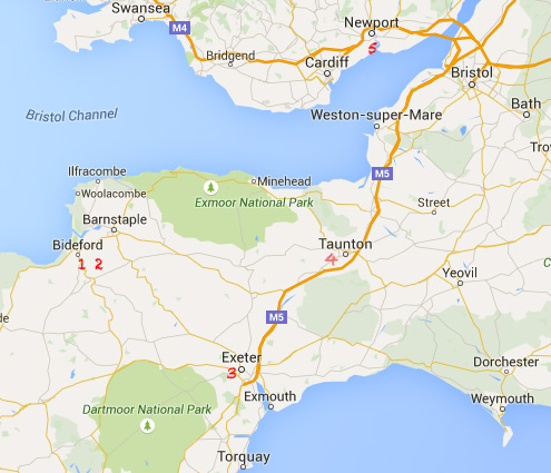 Devon, Somerset and South Wales
 The West Country
In the 1400-1700 period, Brinsmeads lived throughout this area, but all but one family carrying the name died out. The largest early concentration of Brinsmeads came from Bishops' Hull in Somerset (4 on the map). Thomas and Agnes Brinsmead, our brickwall, lived in St. Giles in the Wood (2 on the map). The family basically stayed in St. Giles and surrounds until 1803 when Henry Brinsmead married Elizabeth Beer and moved to nearby Weare Giffard (1 on the map).
The next to leave was Hugh Brinsmead who moved to Exeter where he set up shop as a builder (3 on the map). A few of the Brinsmeads from Weare Giffard moved to Bideford and took to the sea, mostly running coastal vessels, often up the Bristol Channel to Bristol and to Newport in Wales, where eventually George Brinsmead settled and where his daughter Louise married Harry Williams, giving rise to the Brinsmead-Williams line, many of whom still live in the West Country.
North Devon
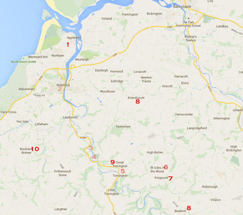 The Great Torrington Area of North Devon
Now we focus a little closer in on the area surrounding Great Torrington (9 on the map). We have reason to believe there were Brinsmeads living in Great torrington during the 1500's. Unfortunately the combination of the English Civil War and World War II destroyed most of the town's records from that period. Situated on top of a hill, the town provides a wonderful view of the area to the east and west. In Summer, visit the castle and museum for a civil war era re-enactment. In February, 1646, well after the Brinsmeads were living a couple of miles away in St. Giles in the Wood (when it actually was a wood), Great Torrington was the site of a major confrontation which marked the end of the Royalist resistance in the West Country.
From Castle Hill, look down at the valley below where the River Torridge runs out to the Bristol Channel through the ancient ports of Appledore and Bideford. In the early 1800's, before the railway, an important canal was built to make this a viable trade route from the town. Robert Brinsmead managed the canal for many years. As you look down the hill, you can also see South Street. It was along that Street in the mid to late 1800's that several Brinsmeads worked as glovers, a major industry at the time. Some worked in small factories. Many others, often farm wives and daughters, did piece work making gloves from their homes.
A popular attraction on Torrington itself is the Dartington Glass factory. Just a little south of the town (5 on the map) are the Royal Horticultural Society's Rosemore Gardens; well worth a visit.
On the west side of the Torridge, as it makes its way to the Bristol Channel, are the two ancient ports of Bideford and Appledore. These harbours were home to the fishing fleets that ran out to the Grand Banks of Newfoundland. In later years, they were also heavily involved in the export of lime, particularly to South Wales across the channel. If you explore the Torridge from Great Torrington to Bideford you will find several examples of Lime Kilns. Henry Brinsmead owned one in Weare Giffard (see below) and some of the boys, including George and John, worked on the kilns or on the boats moving the lime up the river. George Brinsmead married and settled in Bideford here he went to sea and his wife ran a flour merchant's business. however, he went bankrupt and deserted his wife and business, ending up marrying a second time in Liverpool. The business was on Hornstone Lane. Several other Brinsmeads lived for a time in the Bideford and appledore area where they were active in the local Methodist churches.
Buckland Brewer (10 on the map) is a delightful village with a couple of Brinsmead connections. Two of the earliest documents are leases by Thomas Brinsmead for farm land in Buckland Brewer, which suggests he may have been financially well placed. The village was also home to the Squire family that intermarried with the Brinsmeads. The Squires were watchmakers, a craft they passed on to several members of the Brinsmead family. It was one of the Squires from Buckland Brewer who installed the clock in St. Giles in the Wood church when it was heavily renovated in the mid 1800's. There is one Brinsmead grave to be found in the churchyard, a shared grave with others with a brief reference at the bottom of the tombstone. Folks were poor in those days. Buckland Brewer is home to the pre-eminent family historian for the area, Janet Few, well known for her appearances in period costume at local family history events.
The village of Alverdiscott, to the north of St. Giles in the Wood (8 on the map) was home to Henry Brinsmead and his wife Elizabeth. Henry's grave is in the Churchyard, but not Elizabeth's. He was the local blacksmith for decades. Also, Henry and Elizabeth acted as witnesses to virtually every wedding celebrated in the Church.
To the south-east of St. Giles in the Wood is the village of Beaford. It is home to the Globe Inn, an excellent place to stop for lunch. supper, or the traditional pint. The new owners serve excellent meals and are very welcoming. There is, of course, a Brinsmead connection. Henry and Elizabeth's daughter Susannah married a Robert Woolaway. They had a daughter Fanny who married George Westcott. That couple appear to have run the Globe Inn in the 1860's and 1870's. There were members of that family in Beaford into the 1930's and perhaps here still are.
St Giles in the Wood
The map below, although a few years old is still a sufficient guide to the village today. St Giles is spread out over quite a large area, and has a couple of smaller hamlets within its boundary.
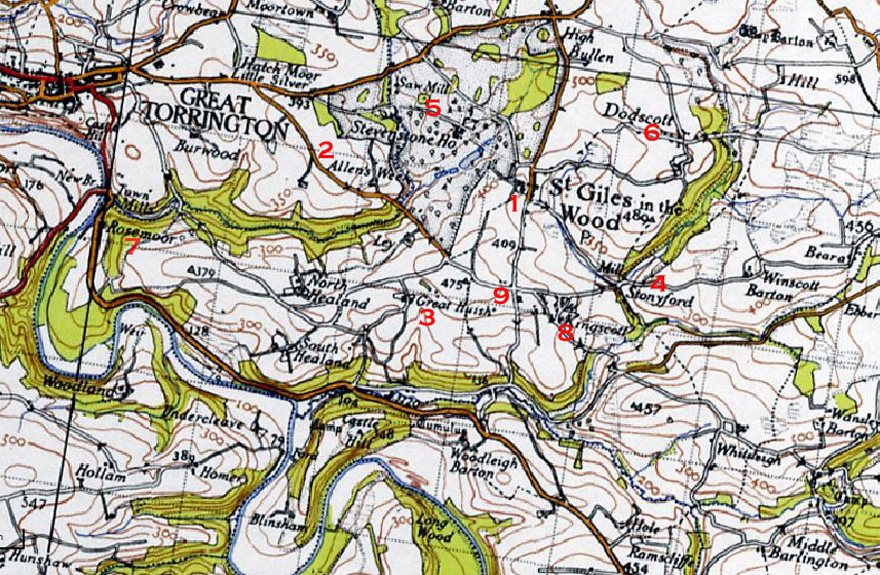 The Village of St. Giles in the Wood
 The Village centre (1 on the map) will be of the most interest. It includes the Parish Church, the house that most of the Brinsmeads lived in at one time or another, since it was the house that passed to the eldest son each generation, and behind that house, what looks like an old stone barn that, when originally built, was the local methodist chapel. There is a farm yard right across from the church gate, and it too was a Brinsmead farm at one point. The Parish Church has no mention of Brinsmeads inside, but there are many family members buried in the churchyard spanning about six generations. Unfortunately, many of the stones have been moved to the South and Western edges of the graveyard for safety and grass cutting reasons but most can be easily read. A square grave is still to be found about 15 yards South of the Church door; that of the last couple with the Brinsmead line in the village, Thomas and Emily. On the North side of the graveyard - to the right as you approach the church, you will find graves for some of the more recent female line descendents - notably Ashplants and Hookways.
As the families grew larger, some moved to farms throughout the village. The reader is referred to the census record pages to see who lived where and when. What follows is only a brief summary. Great Huish farm (3 on the map) was home to Henry Brinsmead who migrated to the Geelong area of Australia. Allens Week farm (2 on the map) was home to William Brinsmead, who also migrated to Geelong and named his farm on Lake Connewara "Allens Week" as well.
Higher House farm (9 on the map) was home to Fanny Brinsmead her husband John Hookway and their large family. It is the house at the crossroads, looking down on the village. The pre-census tax rolls tells us Thomas Brinsmead and Henry Brinsmead leased several farms in the area. Henry Snr. was married to Francis Clarke, a member of one of the oldest families in the village, which is perhaps how they came to live at Clarke's Dodscott (near 6 on the map; there are several farms at Dodscott. It is a large house on a corner - see pictures elsewhere on the web site).
Stoneyford Farm (4 on the map), which had a nearby mill, was home to Hugh Brinsmead before he died, and to his widow and her new husband John Ware thereafter. It is from here that Hugh and Mary Tanton (nee Brinsmead) left for London, Upper Canada.
Kingscott hamlet (8 on the map) became home to Hugh Brinsmead's widow. One of the earliest "pilgrims" was Hugh Brinsmead Jnr. who returned home several times in the early 1900's, taught Sunday school, and tended the garden at the small Chapel in the hamlet.
Rosemore Gardens (7 on the map) is mentioned above as a place well worth a visit for those in the area. When the Brinsmeads lived in St. Giles in the woods, the village would have been dominated by the Rolle family and their home at Stevenstone House (5 on the map). The house itself is long since gone, but a walk down the lane leading into the village takes you past the former stable block, now converted into quite lovely homes. The Rolle family owned most if not all of the land in St Giles, as well as elsewhere throughout Devon, and were therefore the landlords for all the Brinsmead tenants.
Weare Giffard
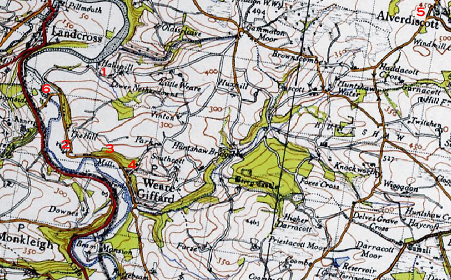 The Village of Weare Giffard
 One enters Weare Giffard after descending a long hill from Great Torrington. The village itself is mostly a single street that ambles along beside the River Torridge as it flows towards the sea. The flat meadowlands by the road are prone to flooding and a number of the cottages along the road have been raised because of this. The cottage believed to have been the Brinsmead home is but one example of this (near 3 on the map). To the left, there is a fine example of a mill. At the point where the village pub - The Cyder Press - stands there is a fork in the road. It is believed the pub owned by Henry and Elizabeth Brinsmead, called the Anchor or the Blue Anchor was up on this road to the right off the main road (4 on the map). Nothing is left of it now and it appears to have closed in the 1860's.
The parish church is located at the turn by the hill (2 on the map). There are several Brinsmead gravestones in the churchyard but nothing about the family in the church itself. From the graveyard, you can get a good look at Weare Giffard Hall, the home of the Giffard and then Fortescue families in former times.
Further along, the main road takes a turn to the left, passing over the Torridge by Half-penny Bridge, named after the amount of the fee charged to cross. To the right, just as you pass the bridge is the best remaining lime kiln in the area - Annery Kiln. Proceed back over the bridge and continue on the road on the north side of the river and follow it round the bend in the river until you get to Hallspill (sometimes Allspill). There is a white cottage behind trees which we believe from the census records to have been owned by the Brinsmeads. Just before the house there is a short pathway to the river. There you will find another lime kiln; this one the Brinsmead's kiln. If you look closely, you can also see the remains of the brick wall where the boats would come in to be loaded with lime to be taken up to Bideford, or further afield.
The village of Alverdiscott (5 on the map) was home to village blacksmith Henry Brinsmead and his wife Elizabeth.
Historically, four important routes have run through Weare Giffard. First and still, is the River Torridge providing power, fishing and transportation. Next came the Rolle canal built to improve the flow of goods from Torrington to the sea. Robert Brinsmead played an important role in managing the canal throughout his career. However, as was the case with many canals, it was eclipsed by the railway which too ran through the valley by the river. The Bideford to Torrington extension to the London and South-Western Railway was opened in 1872 and provided passanger service until 1965. There was never a station at Weare Giffard itself. The railway was built, in part, on the route of the canal and resulted in the removal of Weare Quay which had served the canal traffic. Since the removal of the railway tracks, the rail bed has become part of the now famous Tarka Trail cycle and hiking route. The section of the trail from Torrington to Bideford is 10 kms (6 miles) long and easily walked. It takes you past Weare Giffard and makes a delightful day hike.